Showing posts with label hurricane. Show all posts

Wednesday, September 23, 2009


*****REMINDER*****
THIS FRIDAY


Back in June, I wrote a post on the alarming realities of what would happen if a Category 3 hurricane were to hit the metropolitan area. According to scientists, the storm surge would leave huge parts of the city under water.

If you add to that the reality of rising sea levels, we are talking disaster, especially in the Gowanus and red Hook districts.

Now, the community has the opportunity to hear directly from the expert:


Malcolm Bowman, Ph.D., Professor of Physical Oceanography and a

Distinguished Service Professor at the Marine Sciences Research Center (MSRC) State University of NY at Stony Brook.


Please make time to attend this important event organized by Friends & Residents Of Greater Gowanus, with support from Community Board 6 and numerous other local community groups.


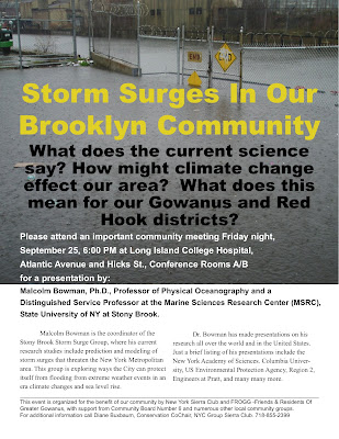
Storm Surges In Our Brooklyn Community


What does the current

science indicate? How might

climate change effect our area? What does this mean

for our Gowanus and

Red Hook districts?


Please attend an important community meeting


Friday night, September 25, 6:00 PM


at Long Island College Hospital,
Atlantic Avenue and Hicks St., Conference Rm A/B
for a presentation by:
Malcolm Bowman, Ph.D., Professor of Physical Oceanography and a

Distinguished Service Professor at the Marine Sciences Research Center (MSRC) State University of NY at Stony Brook.


Malcolm Bowman is the coordinator of the Stony Brook Storm Surge Group, where his current research studies include prediction and modeling of storm surges that threaten the New York Metropolitan area. This group is exploring ways the City can protect itself from flooding from extreme weather events in an era climate changes and sea level rise.

Dr. Bowman has made presentations on his research all over the world and in the United States. Just a brief listing of his presentations include the New York Academy of Sciences. Columbia University, US Environmental Protection Agency, Region 2, Engineers at Pratt, and many many more.


NYC on Storm Surges:

“The U.S. Army Corps of Engineers found that New York City's low-lying, heavily populated neighborhoods are more exposed to the threat of coastal flooding in a hurricane than most people realized.

Large areas of southern Queens, southern Brooklyn, the lower east and west sides of Manhattan, and the perimeter of Staten Island could all suffer damage from a hurricane's storm surge. In addition, storm surge from a strong hurricane would not be limited to waterfront properties and could conceivably push miles inland in some areas. New York City's unique geography — located at a "bend" in the coastline between New Jersey and Long Island — makes it especially vulnerable.

Even a low-level hurricane that makes landfall near New York City could wash ocean waters over large sections of some coastal

neighborhoods.

Storm surge can make landfall five hours before the hurricane itself.

It can also take place after a hurricane has moved away from the city, as high seas slump back into confined spaces like Long Island Sound.”


http://www.nyc.gov/html/oem/html/hazards/storms_stormsurge.shtml


This event is organized for the benefit of our community by New York Sierra Club and FROGG -Friends & Residents Of Greater Gowanus, with support from Community Board 6 and numerous other local community groups. For additional information call Diane Buxbaum, Conservation CoChair, NYC Group Sierra Club. 718-855-2399


Related Reading:


What Would Happen To The Polluted Gowanus Canal In Case Of A Hurricane?


Water, Water, Everywhere: Hurricanes And The Brooklyn Battery Tunnel


For Home Page, click Pardon Me For Asking


Tuesday, June 2, 2009


From the Office Of Emergency Management


hurricane_map_english


hurricane_map_english


hurricane_map_english


OEM_HE_gis-prd-map3470376983


From City Hurricane Preparedness Web Site:

In Case Of Hurricane, Cross The Gowanus Canal To Get To Nearest Evacuation Center


Waves striking a seawall, 1938


(NWS Historic Collection)


So, yesterday was the beginning of the 2009 hurricane season. Which got me thinking...

Hurricanes are rare in New York City, but they do occur. Over the last decade, storms have become stronger, more unpredictable and more frequent. If a Category 3 hurricane were to hit the metropolitan area, it would be a disaster. There is no way to evacuate all inhabitants.

Scientists Cynthia Rosenzweig and Vivien Gornitz, part of a team at NASA's Goddard Institute for Space Studies and New York's Columbia University determined that "rising sea levels combined with the storm surge of a category three hurricane would leave much of a 2050s New York underwater and the city's entire metropolitan transportation system shut down."


Obviously, New York City is taking this seriously. A while back, the Office of Emergency Management sent out a brochure to every household in the city, indicating flood zones, evacuation routes and detailing steps to take in the event of a hurricane.


Why am I bringing this up? Well, after looking at the city flood map, I am more than uneasy about what would happen to the heavily polluted Gowanus Canal in case of a hurricane.

Because flooding, which already occurs regularly in the area, may be the least of our problems.

You see, the toxic sludge at the bottom of the Gowanus would be churned around in the waters of the canal and would be dumped on land. Which, well, would be an incredibly dangerous situation. Even without storm, "there is a constant flux of movement between the water and the sediment" Walter Mugden of the EPA mentioned at a meeting last week. So imagine that same body of water during a category three hurricane.

As a dear friend always says, that would be "like Love Canal and Hurricane Katrina all in one."

Yikes!


Though we cannot significantly reduce the dangers associated with natural disasters, we can support the EPA's listing of the Gowanus Canal as a Superfund site. As part of their clean-up, the EPA would dredge the toxic sludge from the bottom of the canal, which would control the damage which would result from a hurricane.

That, however, is not something that Mayor Bloomberg and our own Councilmember Bill de Blasio are willing to support. No, they were fully willing to have developers build condos in a flood zone, on the banks of a poisoned body of water.

Those against the Superfund complain that the designation could affect house prices in the area. I would venture to say that having toxic sludge on our streets and in our houses after a hurricane would make any building uninhabitable and unsalable for much longer.


So lets hope that the 2009 hurricane season passes without unleashing a major storm over our area, because otherwise, we will all have toxic sludge in our houses.


Oh, and just one last thing:

Why would the hurricane evacuation route indicated by the Office of Emergency Management
take someone from Carroll Gardens over the Gowanus Canal to an Evacuation Center on 4th Avenue?

That is exactly what their web site indicated when I played around with different addresses. (I used number 357 Carroll Street as an example.)

That doesn't make a whole lot of sense now does it?


Hurricanes are a rare occurrence in New York City, so it is understandable that most New York City residents have no idea how vulnerable our coastal city is to the storm surge flooding which follows these massive storms. One only has to look at the


Scary New York Moments

Some of the worst hurricane-related effects in New York's history:

1821: The only hurricane in modern times known to pass directly over parts of New York City pushed the tide up 13 feet in one hour and inundated wharves, causing the East River and the Hudson River to merge across lower Manhattan as far north as Canal Street. Deaths were limited since few lived there at the time.

1893: A category 1 hurricane destroyed Hog Island, a resort island off the Rockaways in southern Queens.

1960: Hurricane Donna created an 11-foot storm tide in the New York Harbor that caused extensive pier damage. Forced 300 families to evacuate Long Island.

1999: Floyd, weakened to a tropical storm, brought sustained 60 mph winds and dumped 10-15 inches of rain on upstate New Jersey and New York State.

2004: The remains of Hurricane Frances in September flooded city subways, stranding some passengers aboard trains that had to be stopped by flooded tracks.

SOURCE: New York City Office of Emergency Management, LiveScience reporting

(from:http://www.livescience.com/environment/050601_hurricane_1938.html)


For Home Page, click Pardon Me For Asking